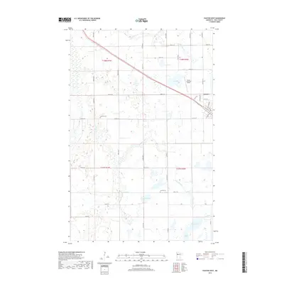
2019 Map of Fosston West
USGS Topo · Published 2019About this map
The Sand Hill River meanders across this landscape in northwestern Minnesota, defining a terrain shaped by glacial activity and modern agriculture. On the western outskirts of Fosston, the map reveals a network of section roads like 400th St SE and 410th St SE that segment the rural countryside into a precise grid. For those tracing family history, the presence of the Landsverk Cem and Hansville Cem provides specific points of interest within the townships of T148N and T147N. The area is dotted with numerous small bodies of water, including Ouff Lake, Strand Lake, and Homme Lake, which are characteristic of the prairie pothole region. The Fosston Municipal Airport sits near the eastern edge, marking a transition between the open fields and the organized streets of the town center.
Find a feature on this map
29 named features on this map. Tap any name to fly to it.
Don’t see what you’re looking for? This feature index may not catch every label — zoom into the map to look around manually.
Map Details
Editions of this 2019 Fosston West Map
This is the sole edition of this map. No revisions or reprints were ever made.
Other maps of this area

1919 · Fosston
USGS Topo · 1:62,500

1954 · Bemidji
USGS Topo · 1:250,000

1957 · Bemidji
USGS Topo · 1:250,000

1958 · Bemidji
USGS Topo · 1:250,000

1969 · Olga
USGS Topo · 1:24,000

1969 · Mc Intosh NE
USGS Topo · 1:24,000

1969 · Fosston East
USGS Topo · 1:24,000
1969 · Mc Intosh
USGS Topo · 1:24,000

1969 · Fosston West
USGS Topo · 1:24,000
1969 · Winger
USGS Topo · 1:24,000