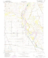
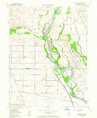
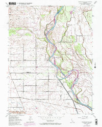
1950 Map of Foster Island
USGS Topo · Published 1969About this map
The Sacramento River meanders through a landscape defined by seasonal water patterns and agricultural development along the Tehama and Glenn county line. Large river features like Foster Island and Snaden Island dominate the central corridor, while land-use patterns show a clear transition from the riparian zones to the irrigation-supported fields near Capay. The mapping reveals the historical importance of river access, marked by sites such as Wilson Landing and McIntosh Ldg, which served as vital transit points before modern road networks were fully established.
Map Details
Editions of this 1950 Foster Island Map
4 editions found
Historical Maps of Capay Through Time
265 maps found

1912 Singer Creek
Tehama County, CA

1914 Kirkwood
Tehama County, CA

1914 McIntosh Landing
Tehama County, CA

1944 Tuscan Buttes
Tehama County, CA

1947 Tuscan Buttes
Tehama County, CA

1949 Colyear Springs
Tehama County, CA

1949 Kirkwood
Tehama County, CA

1950 Foster Island
Tehama County, CA

1950 Kirkwood
Tehama County, CA

1951 Foster Island
Tehama County, CA

1951 Red Bluff East
Tehama County, CA

1951 Red Bluff West
Tehama County, CA

1951 Tuscan Springs
Tehama County, CA

1951 West of Gerber
Tehama County, CA

1952 Anthony Peak
Tehama County, CA

1952 Blossom
Tehama County, CA

1952 Campbell Mound
Tehama County, CA

1952 Red Bank
Tehama County, CA

1952 Red Bank
Tehama County, CA

1952 Richardson Springs NW
Tehama County, CA

1953 Panther Spring
Tehama County, CA

1954 Yolla Bolly
Tehama County, CA

1956 Lassen Peak
Tehama County, CA

1957 Colyear Springs
Tehama County, CA

1965 Hooker
Tehama County, CA

1965 Mitchell Gulch
Tehama County, CA

1967 Ball Mountain
Tehama County, CA

1967 Black Butte Dam
Tehama County, CA

1967 Cold Fork
Tehama County, CA

1967 Hall Ridge
Tehama County, CA

1967 Henleyville
Tehama County, CA

1967 Log Spring
Tehama County, CA

1967 Lowrey
Tehama County, CA

1967 Newville
Tehama County, CA

1967 Oxbow Bridge
Tehama County, CA

1967 Raglin Ridge
Tehama County, CA

1967 Riley Ridge
Tehama County, CA

1967 Sehorn Creek
Tehama County, CA

1981 Beegum
Tehama County, CA

1981 Chickabally Mtn
Tehama County, CA

1981 North Yolla Bolly
Tehama County, CA

1981 South Yolla Bolly
Tehama County, CA

1985 Acorn Hollow
Tehama County, CA

1985 Childs Meadows
Tehama County, CA

1985 Dewitt Peak
Tehama County, CA

1985 Finley Butte
Tehama County, CA

1985 Grays Peak
Tehama County, CA

1985 Inskip Hill
Tehama County, CA

1985 Lassen Peak
Tehama County, CA

1985 Lyonsville
Tehama County, CA

1986 Digger Pine Flat
Tehama County, CA

1986 Panther Spring
Tehama County, CA

1989 Lake Almanor
Tehama County, CA

1991 Barkley Mountain
Tehama County, CA

1991 Devils Parade Ground
Tehama County, CA

1991 Humboldt Peak
Tehama County, CA

1991 Onion Butte
Tehama County, CA

1995 Barkley Mountain
Tehama County, CA

1995 Campbell Mound
Tehama County, CA

1995 Childs Meadows
Tehama County, CA

1995 Deer Creek Flat
Tehama County, CA

1995 Devils Parade Ground
Tehama County, CA

1995 Dewitt Peak
Tehama County, CA

1995 Finley Butte
Tehama County, CA

1995 Grays Peak
Tehama County, CA

1995 Humboldt Peak
Tehama County, CA

1995 Inskip Hill
Tehama County, CA

1995 Lassen Peak
Tehama County, CA

1995 Log Spring
Tehama County, CA

1995 Lyonsville
Tehama County, CA

1995 Newville
Tehama County, CA

1995 Onion Butte
Tehama County, CA

1995 Panther Spring
Tehama County, CA

1995 Raglin Ridge
Tehama County, CA

1995 Riley Ridge
Tehama County, CA

1995 Solomon Peak
Tehama County, CA

1995 South Yolla Bolly Mountains
Tehama County, CA

1996 Ball Mountain
Tehama County, CA

1996 Hall Ridge
Tehama County, CA

1998 Beegum
Tehama County, CA

1998 Cold Fork
Tehama County, CA

1998 North Yolla Bolly Mountains
Tehama County, CA

1998 Tomhead Mountain
Tehama County, CA

2012 Acorn Hollow
Tehama County, CA

2012 Ball Mountain
Tehama County, CA

2012 Barkley Mountain
Tehama County, CA

2012 Beegum
Tehama County, CA

2012 Black Butte Dam
Tehama County, CA

2012 Blossom
Tehama County, CA

2012 Campbell Mound
Tehama County, CA

2012 Chickabally Mountain
Tehama County, CA

2012 Childs Meadows
Tehama County, CA

2012 Cold Fork
Tehama County, CA

2012 Deer Creek Flat
Tehama County, CA

2012 Devils Parade Ground
Tehama County, CA

2012 Dewitt Peak
Tehama County, CA

2012 Finley Butte
Tehama County, CA

2012 Foster Island
Tehama County, CA

2012 Grays Peak
Tehama County, CA

2012 Hall Ridge
Tehama County, CA

2012 Henleyville
Tehama County, CA

2012 Hooker
Tehama County, CA

2012 Humboldt Peak
Tehama County, CA

2012 Inskip Hill
Tehama County, CA

2012 Kirkwood
Tehama County, CA

2012 Lassen Peak
Tehama County, CA

2012 Log Spring
Tehama County, CA

2012 Lowrey
Tehama County, CA

2012 Lyonsville
Tehama County, CA

2012 Mitchell Gulch
Tehama County, CA

2012 Newville
Tehama County, CA

2012 North Yolla Bolly Mountains
Tehama County, CA

2012 Onion Butte
Tehama County, CA

2012 Oxbow Bridge
Tehama County, CA

2012 Panther Spring
Tehama County, CA

2012 Raglin Ridge
Tehama County, CA

2012 Red Bank
Tehama County, CA

2012 Red Bluff East
Tehama County, CA

2012 Red Bluff West
Tehama County, CA

2012 Richardson Springs NW
Tehama County, CA

2012 Riley Ridge
Tehama County, CA

2012 Rosewood
Tehama County, CA

2012 Sehorn Creek
Tehama County, CA

2012 Solomon Peak
Tehama County, CA

2012 South Yolla Bolly Mountains
Tehama County, CA

2012 Tomhead Mountain
Tehama County, CA

2012 Tuscan Springs
Tehama County, CA

2012 West of Gerber
Tehama County, CA

2015 Acorn Hollow
Tehama County, CA

2015 Ball Mountain
Tehama County, CA

2015 Barkley Mountain
Tehama County, CA

2015 Beegum
Tehama County, CA

2015 Black Butte Dam
Tehama County, CA

2015 Blossom
Tehama County, CA

2015 Campbell Mound
Tehama County, CA

2015 Chickabally Mountain
Tehama County, CA

2015 Childs Meadows
Tehama County, CA

2015 Cold Fork
Tehama County, CA

2015 Deer Creek Flat
Tehama County, CA

2015 Devils Parade Ground
Tehama County, CA

2015 Dewitt Peak
Tehama County, CA

2015 Finley Butte
Tehama County, CA

2015 Foster Island
Tehama County, CA

2015 Grays Peak
Tehama County, CA

2015 Hall Ridge
Tehama County, CA

2015 Henleyville
Tehama County, CA

2015 Hooker
Tehama County, CA

2015 Humboldt Peak
Tehama County, CA

2015 Inskip Hill
Tehama County, CA

2015 Kirkwood
Tehama County, CA

2015 Lassen Peak
Tehama County, CA

2015 Log Spring
Tehama County, CA

2015 Lowrey
Tehama County, CA

2015 Lyonsville
Tehama County, CA

2015 Mitchell Gulch
Tehama County, CA

2015 Newville
Tehama County, CA

2015 North Yolla Bolly Mountains
Tehama County, CA

2015 Onion Butte
Tehama County, CA

2015 Oxbow Bridge
Tehama County, CA

2015 Panther Spring
Tehama County, CA

2015 Raglin Ridge
Tehama County, CA

2015 Red Bank
Tehama County, CA

2015 Red Bluff East
Tehama County, CA

2015 Red Bluff West
Tehama County, CA

2015 Richardson Springs NW
Tehama County, CA

2015 Riley Ridge
Tehama County, CA

2015 Rosewood
Tehama County, CA

2015 Sehorn Creek
Tehama County, CA

2015 Solomon Peak
Tehama County, CA

2015 South Yolla Bolly Mountains
Tehama County, CA

2015 Tomhead Mountain
Tehama County, CA

2015 Tuscan Springs
Tehama County, CA

2015 West of Gerber
Tehama County, CA

2018 Acorn Hollow
Tehama County, CA

2018 Ball Mountain
Tehama County, CA

2018 Barkley Mountain
Tehama County, CA

2018 Beegum
Tehama County, CA

2018 Black Butte Dam
Tehama County, CA

2018 Blossom
Tehama County, CA

2018 Campbell Mound
Tehama County, CA

2018 Chickabally Mountain
Tehama County, CA

2018 Childs Meadows
Tehama County, CA

2018 Cold Fork
Tehama County, CA

2018 Deer Creek Flat
Tehama County, CA

2018 Devils Parade Ground
Tehama County, CA

2018 Dewitt Peak
Tehama County, CA

2018 Finley Butte
Tehama County, CA

2018 Foster Island
Tehama County, CA

2018 Grays Peak
Tehama County, CA

2018 Hall Ridge
Tehama County, CA

2018 Henleyville
Tehama County, CA

2018 Hooker
Tehama County, CA

2018 Humboldt Peak
Tehama County, CA

2018 Inskip Hill
Tehama County, CA

2018 Kirkwood
Tehama County, CA

2018 Lassen Peak
Tehama County, CA

2018 Log Spring
Tehama County, CA

2018 Lowrey
Tehama County, CA

2018 Lyonsville
Tehama County, CA

2018 Mitchell Gulch
Tehama County, CA

2018 Newville
Tehama County, CA

2018 North Yolla Bolly Mountains
Tehama County, CA

2018 Onion Butte
Tehama County, CA

2018 Oxbow Bridge
Tehama County, CA

2018 Panther Spring
Tehama County, CA

2018 Raglin Ridge
Tehama County, CA

2018 Red Bank
Tehama County, CA

2018 Red Bluff East
Tehama County, CA

2018 Red Bluff West
Tehama County, CA

2018 Richardson Springs NW
Tehama County, CA

2018 Riley Ridge
Tehama County, CA

2018 Rosewood
Tehama County, CA

2018 Sehorn Creek
Tehama County, CA

2018 Solomon Peak
Tehama County, CA

2018 South Yolla Bolly Mountains
Tehama County, CA

2018 Tomhead Mountain
Tehama County, CA

2018 Tuscan Springs
Tehama County, CA

2018 West of Gerber
Tehama County, CA

2021 Acorn Hollow
Tehama County, CA

2021 Ball Mountain
Tehama County, CA

2021 Beegum
Tehama County, CA

2021 Black Butte Dam
Tehama County, CA

2021 Blossom
Tehama County, CA

2021 Campbell Mound
Tehama County, CA

2021 Chickabally Mountain
Tehama County, CA

2021 Childs Meadows
Tehama County, CA

2021 Deer Creek Flat
Tehama County, CA

2021 Devils Parade Ground
Tehama County, CA

2021 Dewitt Peak
Tehama County, CA

2021 Finley Butte
Tehama County, CA

2021 Foster Island
Tehama County, CA

2021 Grays Peak
Tehama County, CA

2021 Henleyville
Tehama County, CA

2021 Humboldt Peak
Tehama County, CA

2021 Log Spring
Tehama County, CA

2021 Mitchell Gulch
Tehama County, CA

2021 Oxbow Bridge
Tehama County, CA

2021 Raglin Ridge
Tehama County, CA

2021 Riley Ridge
Tehama County, CA

2021 Rosewood
Tehama County, CA

2021 Sehorn Creek
Tehama County, CA

2021 South Yolla Bolly Mountains
Tehama County, CA

2021 Tomhead Mountain
Tehama County, CA

2021 Tuscan Springs
Tehama County, CA

2021 West of Gerber
Tehama County, CA

2022 Barkley Mountain
Tehama County, CA

2022 Cold Fork
Tehama County, CA

2022 Hall Ridge
Tehama County, CA

2022 Hooker
Tehama County, CA

2022 Inskip Hill
Tehama County, CA

2022 Kirkwood
Tehama County, CA

2022 Lassen Peak
Tehama County, CA

2022 Lowrey
Tehama County, CA

2022 Lyonsville
Tehama County, CA

2022 Newville
Tehama County, CA

2022 North Yolla Bolly Mountains
Tehama County, CA

2022 Onion Butte
Tehama County, CA

2022 Panther Spring
Tehama County, CA

2022 Red Bank
Tehama County, CA

2022 Red Bluff East
Tehama County, CA

2022 Red Bluff West
Tehama County, CA

2022 Richardson Springs NW
Tehama County, CA

2022 Solomon Peak
Tehama County, CA

2023 Beegum
Tehama County, CA

2023 Henleyville
Tehama County, CA