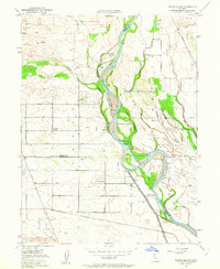
1950 Map of Foster Island
USGS Topo · Published 1963About this map
The Sacramento River carves a complex course through this 1950s landscape, defining the boundaries of Tehama, Butte, and Glenn counties. Large islands such as Foster Island and Snaden Island divide the main channel, while numerous sloughs like Dicks Slough and Snaden Slough illustrate the river's historical shifting paths. The surrounding valley floor is organized into a rigid grid of agricultural roads, including Clark Ave and Capay Ave, supporting the rural communities served by Capay Sch and McIntosh Sch. Evidence of the area's river-based history remains visible at Wilson Landing (Site) and McIntosh Ldg (Site), points that once connected the local economy to the water before the Southern Pacific railroad became the primary transport artery. The presence of several Pumping Sta facilities near the levees highlights the sophisticated irrigation and flood control systems required to manage the fertile but vulnerable land along the riverbanks.
Find a feature on this map
35 named features on this map. Tap any name to fly to it.
Don’t see what you’re looking for? This feature index may not catch every label — zoom into the map to look around manually.
Map Details
Editions of this 1950 Foster Island Map
4 editions found
Other maps of this area

1891 · Chico
USGS Topo · 1:125,000

1893 · Chico
USGS Topo · 1:125,000

1895 · Chico
USGS Topo · 1:125,000

1904 · Vina
USGS Topo · 1:62,500

1906 · Willows
USGS Topo · 1:62,500

1912 · Nord
USGS Topo · 1:31,680

1912 · Chico Landing
USGS Topo · 1:31,680

1912 · Singer Creek
USGS Topo · 1:31,680

1914 · Kirkwood
USGS Topo · 1:31,680

1914 · Orland
USGS Topo · 1:31,680