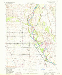
1950 Map of Foster Island
USGS Topo · Published 1971About this map
The Sacramento River carves a complex path through the valley at the junction of Tehama, Glenn, and Butte counties, defining a landscape of shifting waterways and river-dependent commerce. The presence of Wilson Landing (Site) and McIntosh Ldg (Site) points to an era when river transport was central to the region's economy, even as the Southern Pacific railroad and a grid of rural avenues like Capay Ave took over as primary arteries. Large river features such as Foster Island and Snaden Island are surrounded by a network of secondary channels, including Dicus Slough and Harbean Slough, illustrating the dynamic nature of the floodplain. Local education is anchored by the Capay Sch and McIntosh Sch, serving the scattered farmsteads and agricultural plots that fill the flatlands west of the river. To the north, the terrain is marked by smaller drainages like Burch Creek and the quiet waters of Soto Lake.
Find a feature on this map
33 named features on this map. Tap any name to fly to it.
Don’t see what you’re looking for? This feature index may not catch every label — zoom into the map to look around manually.
Map Details
Editions of this 1950 Foster Island Map
4 editions found
Other maps of this area

1891 · Chico
USGS Topo · 1:125,000

1893 · Chico
USGS Topo · 1:125,000

1895 · Chico
USGS Topo · 1:125,000

1904 · Vina
USGS Topo · 1:62,500

1906 · Willows
USGS Topo · 1:62,500

1912 · Nord
USGS Topo · 1:31,680

1912 · Chico Landing
USGS Topo · 1:31,680

1912 · Singer Creek
USGS Topo · 1:31,680

1914 · Kirkwood
USGS Topo · 1:31,680

1914 · Orland
USGS Topo · 1:31,680