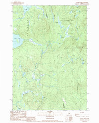
1989 Map of Foster Ridge
USGS Topo · Published 1989About this map
The boundary between Piscataquis and Somerset counties runs through this northern Maine wilderness, characterized by a complex network of wetlands and mountain ponds. The landscape is defined by long, glacial ridges like Foster Ridge and Crockett Ridge that channel the drainage of numerous brooks into bogs and flowages. Significant water bodies such as Austin Pond and Bald Mountain Pond dominate the high ground, while lower elevations are marked by the Kingsley Flowage and Nye Bog. This region was largely undeveloped in the late 1980s, primarily consisting of unorganized territories like Blanchard Plt, Mayfield, and Kingsbury Plt. The presence of a Gravel Pit near the center of the sheet suggests active resource extraction or road maintenance within these timberlands, where many streams like the South Branch Austin Stream provided essential drainage for the surrounding terrain.
Find a feature on this map
42 named features on this map. Tap any name to fly to it.
Don’t see what you’re looking for? This feature index may not catch every label — zoom into the map to look around manually.
Map Details
Editions of this 1989 Foster Ridge Map
This is the sole edition of this map. No revisions or reprints were ever made.
Other maps of this area

1903 · Bingham
USGS Topo · 1:62,500

1905 · Bingham
USGS Topo · 1:62,500

1905 · The Forks
USGS Topo · 1:62,500

1907 · The Forks
USGS Topo · 1:62,500

1948 · Kingsbury
USGS Topo · 1:62,500

1950 · Kingsbury
USGS Topo · 1:62,500

1951 · Greenville
USGS Topo · 1:62,500

1954 · Millinocket
USGS Topo · 1:250,000

1956 · The Forks
USGS Topo · 1:62,500

1956 · Bingham
USGS Topo · 1:62,500
Featured Places
- Blanchard Township, ME
- Kingsbury Plantation, ME
- Bald Mountain Township, ME
- Mayfield Township, ME
- Somerset County, ME