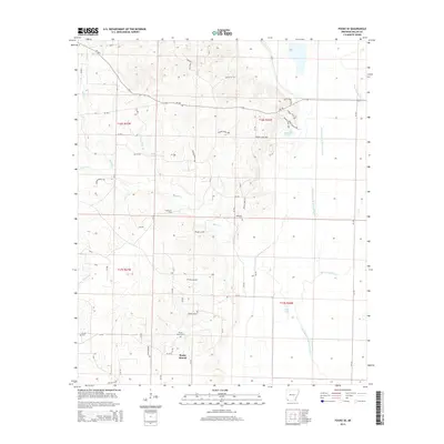
2014 Map of Fouke SE
USGS Topo · Published 2014About this map
Rocky Mound and the small settlement of Holly Springs anchor this portion of Miller County, characterized by a complex network of bayous and creeks. The drainage patterns are dominated by the Old Channel McKinney Bayou, which meanders through the eastern lowlands alongside Moccasin Bayou, while Beech Cr and Holly Springs Br cut through the more elevated western terrain. This area reflects a long-standing rural community structure, indicated by numerous family and community burial grounds such as Fouke Cem, Phylaw Cem, and McKenzie Cem. The presence of the Fouke Oil Field suggests a landscape shaped not only by its waterways but also by subsurface mineral extraction. The map provides a detailed view of the localized road systems, from state routes like Ar-196 to numerous numbered county roads and private timber or oil access routes.
Find a feature on this map
63 named features on this map. Tap any name to fly to it.
Don’t see what you’re looking for? This feature index may not catch every label — zoom into the map to look around manually.
Map Details
Editions of this 2014 Fouke SE Map
This is the sole edition of this map. No revisions or reprints were ever made.
Other maps of this area

1952 · Mandeville
USGS Topo · 1:24,000

1952 · Garland
USGS Topo · 1:24,000

1952 · Doddridge NW
USGS Topo · 1:24,000

1952 · Fouke SE
USGS Topo · 1:24,000

1952 · Doddridge NE
USGS Topo · 1:24,000

1952 · Fouke
USGS Topo · 1:24,000

1952 · Canfield
USGS Topo · 1:24,000

1952 · Fouke NE
USGS Topo · 1:24,000

1952 · Boyd Hill
USGS Topo · 1:24,000

1953 · El Dorado
USGS Topo · 1:250,000