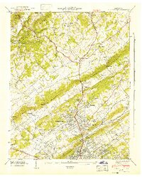
1941 Map of Fountain City
USGS Topo · Published 1941About this map
The Tennessee Valley Authority and Geological Survey produced this topographic study during a period of significant regional transformation, documenting the landscape north of Knoxville. The Norris Freeway cuts through the ridges, representing modern infrastructure amidst a network of older thoroughfares like Maynardville Pike and Emory Road. This era shows a dense social fabric of rural life, anchored by numerous country churches such as Beaver Creek Ch and Bright Hope Ch, alongside small schoolhouses like Fort Sumter Sch and Green Hill Sch.
Find a feature on this map
118 named features on this map. Tap any name to fly to it.
Don’t see what you’re looking for? This feature index may not catch every label — zoom into the map to look around manually.
Map Details
Editions of this 1941 Fountain City Map
This is the sole edition of this map. No revisions or reprints were ever made.
Other maps of this area

1886 · Knoxville
USGS Topo · 1:125,000

1892 · Knoxville
USGS Topo · 1:125,000

1893 · Briceville
USGS Topo · 1:125,000

1894 · Knoxville
USGS Topo · 1:125,000

1895 · Loudon
USGS Topo · 1:125,000

1895 · Briceville
USGS Topo · 1:125,000

1895 · Knoxville
USGS Topo · 1:125,000

1896 · Briceville
USGS Topo · 1:125,000

1897 · Maynardville
USGS Topo · 1:125,000

1900 · Maynardville
USGS Topo · 1:125,000