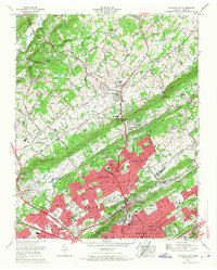
1966 Map of Fountain City
USGS Topo · Published 1968About this map
Blackoak Ridge and Beaver Ridge define the northeast-to-southwest grain of the Knoxville suburbs in the mid-1960s, a period of rapid residential expansion. This Tennessee Valley Authority survey captures Fountain City and Halls Crossroads as established centers amidst growing developments like Harrill Hills and Shannondale. The landscape is a mix of traditional rural crossroads and modern infrastructure, including the newly mapped Freeway (Interstate 75) cutting through Dutch Valley. Local institutional history is anchored by the Beverly Hills Sanatorium and Central High School, while recreation areas such as Whittle Springs Golf Club and the Beaver Brook Country Club reflect the changing land use of the era. Genealogists will find a wealth of family-named landmarks, from the Mynatt Cem to Wallace Cem, scattered among the ridges and valleys.
Find a feature on this map
94 named features on this map. Tap any name to fly to it.
Don’t see what you’re looking for? This feature index may not catch every label — zoom into the map to look around manually.
Map Details
Editions of this 1966 Fountain City Map
This is the sole edition of this map. No revisions or reprints were ever made.
Other maps of this area

1886 · Knoxville
USGS Topo · 1:125,000

1892 · Knoxville
USGS Topo · 1:125,000

1893 · Briceville
USGS Topo · 1:125,000

1894 · Knoxville
USGS Topo · 1:125,000

1895 · Loudon
USGS Topo · 1:125,000

1895 · Briceville
USGS Topo · 1:125,000

1895 · Knoxville
USGS Topo · 1:125,000

1896 · Briceville
USGS Topo · 1:125,000

1897 · Maynardville
USGS Topo · 1:125,000

1900 · Maynardville
USGS Topo · 1:125,000