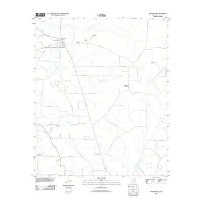
2011 Map of Fountain Hill
USGS Topo · Published 2011About this map
Fountain Hill serves as the primary settlement in this corner of Ashley County, situated at a junction where several local routes meet. The landscape is defined by its numerous small burial grounds and a dense network of winding waterways. Genealogists can identify family sites like Kirkpatrick Cemetery and Norris Hill Cemetery located near the small community of Roark. The area's geography is shaped by the drainage of Fountain Creek and Chemin-A-Haut Creek, which thread through the rural timberlands and small clearings of Fountain Prairie. Further south, Judson Cemetery and Spring Hill Cemetery mark established points of interest among the network of rural roads such as Ashley Road 490 and Valle Rd.
Find a feature on this map
58 named features on this map. Tap any name to fly to it.
Don’t see what you’re looking for? This feature index may not catch every label — zoom into the map to look around manually.
Map Details
Editions of this 2011 Fountain Hill Map
This is the sole edition of this map. No revisions or reprints were ever made.
Other maps of this area

1935 · Mist
USGS Topo · 1:62,500

1935 · Wilmot
USGS Topo · 1:62,500

1952 · Fountain Hill
USGS Topo · 1:24,000

1953 · Greenwood
USGS Topo · 1:250,000

1956 · Greenwood
USGS Topo · 1:250,000

1960 · Mist
USGS Topo · 1:62,500

1960 · Wilmot
USGS Topo · 1:62,500

1960 · Wilmot NW
USGS Topo · 1:24,000
1960 · Mist
USGS Topo · 1:24,000
1960 · Mist NW
USGS Topo · 1:24,000