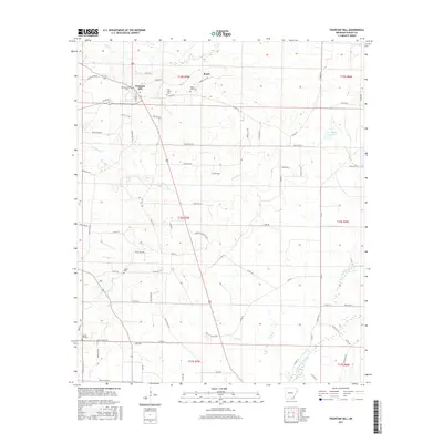
2017 Map of Fountain Hill
USGS Topo · Published 2017About this map
Fountain Hill serves as the primary settlement hub for this corner of Ashley County, situated at the junction of several key local routes including Wilson Rd and Ashley Road 85. The landscape is defined by the winding paths of Fountain Cr and Flat Cr, which drain the lowlands between the scattered farming communities. Significant genealogical value is found in the high density of small burial grounds, such as Kirkpatrick Cem, Flat Creek Cem, and Norris Hill Cem, which are often the only remaining indicators of early family homesteads in the Roark area. To the southeast, the terrain transitions toward the wetlands of Chemin-A-Haut Cr, while smaller water features like Shiloh Lake provide landmarks within the extensive grid of county roads that have come to define modern rural Arkansas transit.
Find a feature on this map
78 named features on this map. Tap any name to fly to it.
Don’t see what you’re looking for? This feature index may not catch every label — zoom into the map to look around manually.
Map Details
Editions of this 2017 Fountain Hill Map
This is the sole edition of this map. No revisions or reprints were ever made.
Other maps of this area

1935 · Mist
USGS Topo · 1:62,500

1935 · Wilmot
USGS Topo · 1:62,500

1952 · Fountain Hill
USGS Topo · 1:24,000

1953 · Greenwood
USGS Topo · 1:250,000

1956 · Greenwood
USGS Topo · 1:250,000

1960 · Mist
USGS Topo · 1:62,500

1960 · Wilmot
USGS Topo · 1:62,500

1960 · Wilmot NW
USGS Topo · 1:24,000
1960 · Mist
USGS Topo · 1:24,000
1960 · Mist NW
USGS Topo · 1:24,000