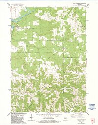
1983 Map of Four Corners
USGS Topo · Published 1984About this map
The Black River defines the northwestern corner of this territory, where the village of Melrose and Stevens Lake sit near the transition from river bottomlands to the rising coulee country. The landscape is characterized by a complex network of ridges and narrow valleys, such as German Valley and Fleming Browns Valley, which dictated the early placement of rural homesteads and roads. Named high points including Twin Peaks, Wadels Hill, and Hippler Hill punctuate the horizon, illustrating the driftless area's distinctive topography.
Find a feature on this map
47 named features on this map. Tap any name to fly to it.
Don’t see what you’re looking for? This feature index may not catch every label — zoom into the map to look around manually.
Map Details
Editions of this 1983 Four Corners Map
This is the sole edition of this map. No revisions or reprints were ever made.
Other maps of this area

1909 · Sparta
USGS Topo · 1:62,500

1926 · North Bend
USGS Topo · 1:62,500

1927 · La Crosse
USGS Topo · 1:62,500

1928 · Melrose
USGS Topo · 1:48,000

1929 · North Bend
USGS Topo · 1:62,500

1930 · La Crosse
USGS Topo · 1:62,500

1947 · Sparta
USGS Topo · 1:62,500

1949 · Sparta
USGS Topo · 1:62,500

1949 · Melrose
USGS Topo · 1:62,500

1953 · Eau Claire
USGS Topo · 1:250,000