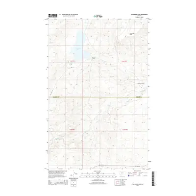
2014 Map of Four Horns Lake
USGS Topo · Published 2014About this map
Four Horns Lake dominates this Montana landscape along the border of Glacier and Pondera counties. The area is defined by a network of drainage features known locally as coulees, including Rocky Ridge Coulee, Big Plum Coulee, Jackson Coulee, and Tall Feather Coulee. These geographical depressions, along with Blacktail Creek, illustrate the hydrologic patterns of the high plains just east of the mountain front. Human intervention in the landscape is visible through the Four Horns Outlet Canal, which manages the waters of the central lake. Access to this remote region is limited to a few thoroughfares such as Birch Creek Road and the Rocky Ridge Trail, reflecting a sparse settlement pattern focused on land management and irrigation in the early 21st century.
Find a feature on this map
14 named features on this map. Tap any name to fly to it.
Don’t see what you’re looking for? This feature index may not catch every label — zoom into the map to look around manually.
Map Details
Editions of this 2014 Four Horns Lake Map
This is the sole edition of this map. No revisions or reprints were ever made.
Other maps of this area

1914 · Heart Butte
USGS Topo · 1:125,000

1918 · Heart Butte
USGS Topo · 1:125,000

1960 · Cut Bank
USGS Topo · 1:250,000

1963 · Cut Bank
USGS Topo · 1:250,000

1964 · Cut Bank
USGS Topo · 1:250,000
1968 · Piegan
USGS Topo · 1:24,000

1968 · Fish Lake
USGS Topo · 1:24,000

1968 · White Man Coulee
USGS Topo · 1:24,000
1968 · Rocky Ridge
USGS Topo · 1:24,000
1968 · Dupuyer West
USGS Topo · 1:24,000