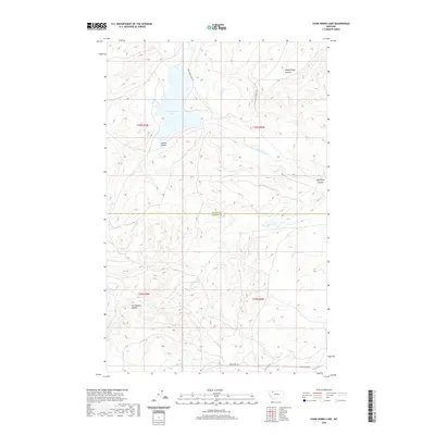
2020 Map of Four Horns Lake
USGS Topo · Published 2020About this map
Four Horns Lake dominates the northern landscape of this region on the border of Glacier and Pondera Counties. This water management and natural drainage system is defined by the Four Horns Outlet Canal and the winding course of Blacktail Cr. The terrain is deeply etched by a series of geographic depressions, including Jackson Coulee and Tail Feather Coulee, which characterize the high plains transition. Transport in this area relies on a network of unpaved routes such as the Four Horns Lake Trl and Rocky Ridge Trl, providing access to the remote coulees and ridges. The boundary between Glacier County and Pondera County bisects the map, showing the intersection of local jurisdictions amidst the undulating landforms of Rocky Ridge Coulee and Big Plum Coulee.
Find a feature on this map
16 named features on this map. Tap any name to fly to it.
Don’t see what you’re looking for? This feature index may not catch every label — zoom into the map to look around manually.
Map Details
Editions of this 2020 Four Horns Lake Map
This is the sole edition of this map. No revisions or reprints were ever made.
Other maps of this area

1914 · Heart Butte
USGS Topo · 1:125,000

1918 · Heart Butte
USGS Topo · 1:125,000

1960 · Cut Bank
USGS Topo · 1:250,000

1963 · Cut Bank
USGS Topo · 1:250,000

1964 · Cut Bank
USGS Topo · 1:250,000
1968 · Piegan
USGS Topo · 1:24,000

1968 · Fish Lake
USGS Topo · 1:24,000

1968 · White Man Coulee
USGS Topo · 1:24,000
1968 · Rocky Ridge
USGS Topo · 1:24,000
1968 · Dupuyer West
USGS Topo · 1:24,000