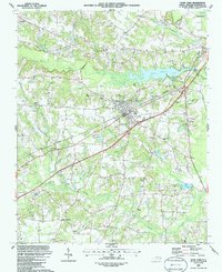
1986 Map of Four Oaks
USGS Topo · Published 1986About this map
Four Oaks serves as the central hub of this mid-1980s landscape, where the Seaboard railroad cuts diagonally through the terrain. The community’s educational and social life is anchored by the Four Oaks High School and a dense network of country churches, including Barbour Chapel and Juniper Grove Ch. Beyond the town center, the area is defined by its complex hydrology, with the Neuse River in the northeast and extensive wetlands like Gum Swamp and Beaverdam Swamp feeding into the Black Creek system. This map reveals a transition from traditional rural crossroads like Allens Crossroads to modern developments, evidenced by the numerous sandpits and the recreational waters of Holts Lake. Genealogists will find particular value in the numerous unnamed cemeteries (Cem) scattered throughout the agricultural plots and woodlands, marking the deep-rooted family settlements of this Johnston County region.
Find a feature on this map
41 named features on this map. Tap any name to fly to it.
Don’t see what you’re looking for? This feature index may not catch every label — zoom into the map to look around manually.
Map Details
Editions of this 1986 Four Oaks Map
This is the sole edition of this map. No revisions or reprints were ever made.
Other maps of this area

1906 · Four Oaks
USGS Topo · 1:48,000

1908 · Four Oaks
USGS Topo · 1:62,500

1953 · Raleigh
USGS Topo · 1:250,000

1954 · Raleigh
USGS Topo · 1:250,000

1964 · Selma
USGS Topo · 1:62,500

1964 · Edmondson
USGS Topo · 1:24,000

1964 · Garner
USGS Topo · 1:62,500

1964 · Powhatan
USGS Topo · 1:24,000

1964 · Selma
USGS Topo · 1:24,000

1973 · Benson
USGS Topo · 1:24,000