
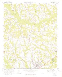
1973 Map of Benson
USGS Topo · Published 1975About this map
Benson serves as the focal point of this 1970s survey, situated along the Seaboard Coast Line railroad in southern Johnston County. The landscape is defined by the branching tributaries of the Black River and Mingo Swamp, showing a rural network of named crossroads and hamlets such as Clifton, Hardee Cross Roads, and Woodall. Notable for genealogists, the map reveals a high density of country churches and community landmarks, including St Marys Grove Ch, Stevens Chapel, and Ebenezer Ch. The era's local culture is marked by the Drive-in Theater just north of town and the South Johnston High Sch to the east. Unique to this sheet are the notations of elliptical bay outlines and field lines visible from aerial photography, providing a layered view of the agricultural and natural geography of the North Carolina coastal plain.
Find a feature on this map
43 named features on this map. Tap any name to fly to it.
Don’t see what you’re looking for? This feature index may not catch every label — zoom into the map to look around manually.
Map Details
Editions of this 1973 Benson Map
2 editions found
Other maps of this area

1906 · Four Oaks
USGS Topo · 1:48,000

1908 · Four Oaks
USGS Topo · 1:62,500

1953 · Raleigh
USGS Topo · 1:250,000

1954 · Raleigh
USGS Topo · 1:250,000

1964 · Selma
USGS Topo · 1:62,500

1964 · Angier
USGS Topo · 1:24,000

1964 · Edmondson
USGS Topo · 1:24,000

1964 · Garner
USGS Topo · 1:62,500

1964 · Powhatan
USGS Topo · 1:24,000

1973 · Dunn
USGS Topo · 1:24,000