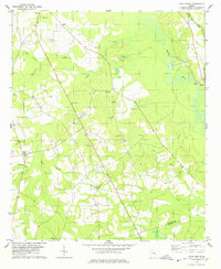
1978 Map of Four Points
USGS Topo · Published 1978About this map
Four Points and its surrounding rural landscapes in Jenkins and Bulloch Counties are defined by a network of Baptist and Methodist congregations and family burial grounds. The agricultural character of the late 1970s is evident in the numerous small churches like Elam Ch, Long Branch Ch, and Gays Hill Ch that anchor local communities. This survey documents the winding course of the Ogeechee River and its many tributaries, including Sculls Creek and Gall Creek, which drain the low-lying terrain. The Central of Georgia railroad runs along the eastern edge, passing through areas of industrial activity such as the Sandpit and Claypit. Genealogists will find significant value in the documentation of numerous named family cemeteries, such as the Aycock Cem and Lanier Cem, which remain as persistent landmarks in this rural Georgia landscape.
Find a feature on this map
45 named features on this map. Tap any name to fly to it.
Don’t see what you’re looking for? This feature index may not catch every label — zoom into the map to look around manually.
Map Details
Editions of this 1978 Four Points Map
This is the sole edition of this map. No revisions or reprints were ever made.
Other maps of this area

1920 · Millen
USGS Topo · 1:62,500

1921 · Rocky Ford
USGS Topo · 1:62,500

1943 · Rocky Ford
USGS Topo · 1:62,500

1943 · Millen
USGS Topo · 1:62,500

1943 · Millen
USGS Topo · 1:125,000

1947 · Savannah
USGS Topo · 1:250,000

1948 · Savannah
USGS Topo · 1:250,000

1957 · Macon
USGS Topo · 1:250,000

1957 · Savannah
USGS Topo · 1:250,000

1958 · Macon
USGS Topo · 1:250,000