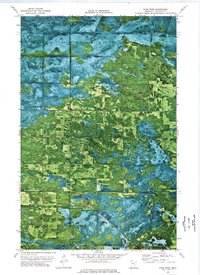
1973 Map of Four Town
USGS Topo · Published 1976About this map
Beltrami Island State Forest and the Red Lake State Wildlife Management Area dominate the northern landscape of this orthophotomap, where the interface of managed wilderness and small-scale agriculture is clearly visible. The settlement of Four Town serves as a local hub, supported by the Four Town Chapel and a Winter Trail cutting through the lowlands of Steenerson. Further north, the vanished or sparse nature of earlier habitation is marked by the Cem near Malcolm and the Linder Lookout Tower standing watch over the timber. This 1970s survey uses aerial photography to detail the drainage patterns and township grids across Spruce Grove, Minnie, Hamre, and Steenerson, providing a precise record of land use before modern reforestation and agricultural shifts altered these Beltrami County communities.
Find a feature on this map
15 named features on this map. Tap any name to fly to it.
Don’t see what you’re looking for? This feature index may not catch every label — zoom into the map to look around manually.
Map Details
Editions of this 1973 Four Town Map
This is the sole edition of this map. No revisions or reprints were ever made.
Other maps of this area

1918 · F
USGS Topo · 1:62,500

1918 · Malcolm
USGS Topo · 1:62,500

1918 · Jelle
USGS Topo · 1:62,500

1954 · Roseau
USGS Topo · 1:250,000

1957 · Roseau
USGS Topo · 1:250,000

1958 · Roseau
USGS Topo · 1:250,000

1973 · Gates Corner
USGS Topo · 1:24,000

1973 · Jelle NE
USGS Topo · 1:24,000

1973 · Thorhult
USGS Topo · 1:24,000
1973 · Shilling Dam NW
USGS Topo · 1:24,000