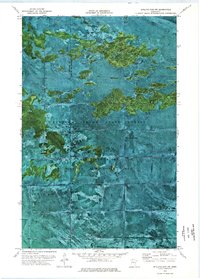
1973 Map of Shilling Dam NW
USGS Topo · Published 1976About this map
Beltrami Island State Forest and the Red Lake State Wildlife Management Area dominate this orthophotomap, showing a complex mosaic of marshland and wooded islands in Northern Minnesota. Produced from 1969 aerial photography, the map captures the transition across the border between Beltrami Co and Lake of the Woods Co. The land is defined by seasonal access and specialized resource extraction, as evidenced by the long Winter Trail cutting through the center and an isolated Gravel Pit near the boundary of the Red Lake Indian Reservation. This map serves as an excellent study of wetland patterns and land management boundaries in a wilderness area where formal roads are scarce, relying instead on seasonal trails to traverse the difficult terrain.
Find a feature on this map
6 named features on this map. Tap any name to fly to it.
Don’t see what you’re looking for? This feature index may not catch every label — zoom into the map to look around manually.
Map Details
Editions of this 1973 Shilling Dam NW Map
This is the sole edition of this map. No revisions or reprints were ever made.
Other maps of this area

1918 · Winterroad
USGS Topo · 1:62,500

1918 · F
USGS Topo · 1:62,500

1918 · Malcolm
USGS Topo · 1:62,500

1954 · Roseau
USGS Topo · 1:250,000

1957 · Roseau
USGS Topo · 1:250,000

1958 · Roseau
USGS Topo · 1:250,000
1968 · Mulligan Lake
USGS Topo · 1:24,000
1969 · Winter Road Lake SE
USGS Topo · 1:24,000
1969 · Winter Road Lake SW
USGS Topo · 1:24,000

1973 · Gates Corner
USGS Topo · 1:24,000