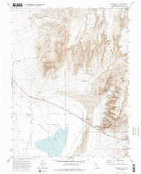
1972 Map of Fourmile Flat
USGS Topo · Published 1985About this map
Fourmile Flat (Alkali) and the arid expanse of the Salt Wells Basin dominate this Churchill County landscape as it was documented in the early 1970s. The region is a study in desert survival and western transit, centered on the stark Sand Dunes and the prominent Sand Mountain. Historical transit is anchored by the Historical Marker (Site of Sand Springs Pony Express Station), a critical waypoint along the central Nevada corridor. Industrial attempts to tap the basin's minerals are evident at the Borax site and various Prospects scattered near the foothills of the Stillwater Range. Resource management in this harsh environment is marked by isolated water sources like Tunnel Spring Windmill and Sand Springs, while a lone Grave along the road provides a poignant reminder of the area's difficult history.
Find a feature on this map
18 named features on this map. Tap any name to fly to it.
Don’t see what you’re looking for? This feature index may not catch every label — zoom into the map to look around manually.
Map Details
Editions of this 1972 Fourmile Flat Map
3 editions found
Other maps of this area

1908 · Carson Sink
USGS Topo · 1:250,000

1910 · Carson Sink
USGS Topo · 1:250,000

1951 · Carson Lake
USGS Topo · 1:62,500

1951 · Allen Springs
USGS Topo · 1:62,500

1957 · Reno
USGS Topo · 1:250,000

1959 · Reno
USGS Topo · 1:250,000

1960 · Reno
USGS Topo · 1:250,000

1972 · Fourmile Flat
USGS Topo · 1:24,000

1972 · Diamond Canyon
USGS Topo · 1:24,000
1972 · Frenchman
USGS Topo · 1:24,000