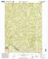
1996 Map of Fourth of July Creek
USGS Topo · Published 1999About this map
The Winchuck River and its numerous tributaries, including the East Fork Winchuck River and the namesake Fourth of July Creek, dominate this portion of the Siskiyou National Forest in Curry County. This 1990s revision reveals a landscape defined by sharp elevation changes between peaks like Elk Mountain and Packsaddle Mountain. Settlement is sparse in this protected area, though the presence of the Ludlum House and the Ludlum Place (Site) near the river offers a specific point of interest for local history researchers and genealogists tracing early inhabitants or forestry outposts in the region.
Find a feature on this map
25 named features on this map. Tap any name to fly to it.
Don’t see what you’re looking for? This feature index may not catch every label — zoom into the map to look around manually.
Map Details
Editions of this 1996 Fourth of July Creek Map
This is the sole edition of this map. No revisions or reprints were ever made.
Other maps of this area

1917 · Kerby
USGS Topo · 1:125,000

1918 · Kerby
USGS Topo · 1:125,000

1922 · Preston Peak
USGS Topo · 1:125,000

1929 · Crescent City
USGS Topo · 1:125,000

1945 · Kerby
USGS Topo · 1:125,000

1945 · Gasquet
USGS Topo · 1:62,500

1945 · Point St. George
USGS Topo · 1:62,500

1948 · Weed
USGS Topo · 1:250,000

1949 · Eureka
USGS Topo · 1:250,000

1950 · Weed
USGS Topo · 1:250,000