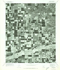
1971 Map of Fowler
USGS Topo · Published 1972About this map
Phoenix extends its suburban footprint into the agricultural landscape of Maricopa County in this early 1970s orthophotomosaic. The map illustrates a stark transition between the expanding residential grids in the north and the established section-line farming plots of Fowler and Santa Maria to the south. This aerial perspective reveals the geometric precision of the valley's irrigation and land use patterns, providing a visual record of the area's development before the intensification of modern sprawl. The southern portion of the quadrangle is defined by the broad, braided path of the Salt River, which carves through the desert floor and dictates the limits of the surrounding cultivation. For those studying the evolution of the Salt River Valley, the imagery provides an unfiltered look at the landscape's transformation from rural outskirts to part of the metropolitan core.
Find a feature on this map
4 named features on this map. Tap any name to fly to it.
Don’t see what you’re looking for? This feature index may not catch every label — zoom into the map to look around manually.
Map Details
Editions of this 1971 Fowler Map
This is the sole edition of this map. No revisions or reprints were ever made.
Other maps of this area

1912 · Phoenix
USGS Topo · 1:62,500

1914 · Phoenix
USGS Topo · 1:62,500

1946 · Avondale
USGS Topo · 1:62,500

1948 · Cashion
USGS Topo · 1:62,500

1952 · Lone Butte
USGS Topo · 1:24,000

1952 · Laveen
USGS Topo · 1:24,000

1952 · Phoenix
USGS Topo · 1:24,000

1952 · Fowler
USGS Topo · 1:24,000

1952 · Phoenix
USGS Topo · 1:62,500

1954 · Phoenix
USGS Topo · 1:250,000