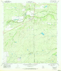
1969 Map of Fowlerton
USGS Topo · Published 1972About this map
The town of Fowlerton sits at the heart of this South Texas cattle country and riparian landscape, positioned along a primary roadway near the Frio River. During the late 1960s, the area relied heavily on localized water resources, evidenced by the numerous named water features including Mangas Flowing Well, Alligator Lake, and several stock tanks like Sauce Verde Tank. The topography reveals a transition from the river lowlands to the elevated Koon Hill and the rolling terrain punctuated by Sevenmile Creek and Galinda Creek.
Find a feature on this map
24 named features on this map. Tap any name to fly to it.
Don’t see what you’re looking for? This feature index may not catch every label — zoom into the map to look around manually.
Map Details
Editions of this 1969 Fowlerton Map
This is the sole edition of this map. No revisions or reprints were ever made.
Other maps of this area

1930 · Tilden
USGS Topo · 1:62,500

1942 · Fowlerton
USGS Topo · 1:62,500

1942 · Tilden
USGS Topo · 1:62,500

1953 · Crystal City
USGS Topo · 1:250,000

1955 · Crystal City
USGS Topo · 1:250,000

1956 · Hindes
USGS Topo · 1:62,500

1956 · Franklin Settlement
USGS Topo · 1:62,500

1956 · Fowlerton
USGS Topo · 1:62,500

1961 · Crystal City
USGS Topo · 1:250,000

1968 · Crystal City
USGS Topo · 1:250,000