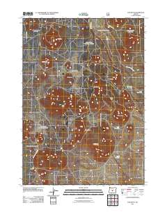
2011 Map of Fox Butte
USGS Topo · Published 2011About this map
Deschutes National Forest encompasses this high-elevation landscape, where volcanic geology is revealed through a dense collection of cinder cones and prominent peaks. Significant summits such as Fox Butte, Aspen Butte, and the uniquely named Moohoo'oo Mountain dot the terrain, while the southwestern corner is defined by the geological depression known as The Blowouts. Human presence in this timbered region is marked by isolated landmarks and water management infrastructure, including Glen Cabin and a series of high-desert basins like Kitteredge Reservoir and West Reservoir. The map illustrates a network of forest roads, such as Watkins Butte Rd, which navigate the various flats and ridges like Porcupine Flat and Hoona Ridge, providing a detailed look at the resource management and natural features of this Oregon wilderness at the start of the 21st century.
Find a feature on this map
20 named features on this map. Tap any name to fly to it.
Don’t see what you’re looking for? This feature index may not catch every label — zoom into the map to look around manually.
Map Details
Editions of this 2011 Fox Butte Map
This is the sole edition of this map. No revisions or reprints were ever made.
Other maps of this area

1955 · Crescent
USGS Topo · 1:250,000

1957 · Crescent
USGS Topo · 1:250,000

1958 · Crescent
USGS Topo · 1:250,000

1970 · Crescent
USGS Topo · 1:250,000

1981 · Fox Butte
USGS Topo · 1:24,000

1981 · Hogback Butte
USGS Topo · 1:24,000

1981 · Cougar Mtn
USGS Topo · 1:24,000
1981 · Plot Butte
USGS Topo · 1:24,000
1982 · Sixteen Butte
USGS Topo · 1:24,000
1982 · Firestone Butte
USGS Topo · 1:24,000