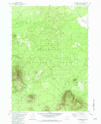
1982 Map of Firestone Butte
USGS Topo · Published 1982About this map
Quartz Mountain dominates the southeastern corner of this landscape within the Deschutes National Forest, rising sharply above a terrain defined by volcanic features and high-elevation openings. The map reveals a land utilized for its natural resources, indicated by the Cinder Pit near Ground Hog Butte and another situated directly on the slopes of Firestone Butte. A network of 4wd roads provides the primary access through these timbered uplands, connecting points of interest like the Lookout Tower on East Butte.
Find a feature on this map
13 named features on this map. Tap any name to fly to it.
Don’t see what you’re looking for? This feature index may not catch every label — zoom into the map to look around manually.
Map Details
Editions of this 1982 Firestone Butte Map
This is the sole edition of this map. No revisions or reprints were ever made.
Other maps of this area

1931 · Newberry Crater
USGS Topo · 1:125,000

1935 · Newberry Crater
USGS Topo · 1:125,000

1955 · Crescent
USGS Topo · 1:250,000

1957 · Crescent
USGS Topo · 1:250,000

1958 · Crescent
USGS Topo · 1:250,000

1966 · Millican SE
USGS Topo · 1:24,000
1967 · Evans Well
USGS Topo · 1:24,000
1967 · Pine Mountain
USGS Topo · 1:24,000

1970 · Crescent
USGS Topo · 1:250,000

1981 · Fox Butte
USGS Topo · 1:24,000