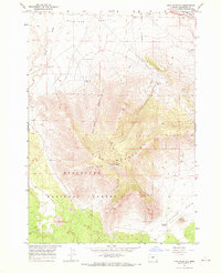
1967 Map of Pine Mountain
USGS Topo · Published 1969About this map
Pine Mountain dominates this mid-1960s landscape, serving as a significant high point within the Deschutes National Forest. The presence of the Pine Mountain Observatory (University of Oregon) and a nearby Lookout Tower marks the summit as a center for both scientific observation and forest management. This high-altitude terrain is contrasted by the broad expanse of the Millican Valley to the north and the Kotzman Basin to the southeast, illustrating the varied topography of central Oregon's high desert country.
Find a feature on this map
18 named features on this map. Tap any name to fly to it.
Don’t see what you’re looking for? This feature index may not catch every label — zoom into the map to look around manually.
Map Details
Editions of this 1967 Pine Mountain Map
3 editions found
Other maps of this area

1931 · Newberry Crater
USGS Topo · 1:125,000

1935 · Newberry Crater
USGS Topo · 1:125,000

1955 · Crescent
USGS Topo · 1:250,000

1957 · Crescent
USGS Topo · 1:250,000

1958 · Crescent
USGS Topo · 1:250,000

1966 · Millican SE
USGS Topo · 1:24,000
1967 · West Butte
USGS Topo · 1:24,000
1967 · Horse Ridge
USGS Topo · 1:24,000
1967 · Evans Well
USGS Topo · 1:24,000
1967 · Millican
USGS Topo · 1:24,000