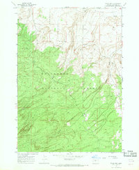
1967 Map of Evans Well
USGS Topo · Published 1969About this map
Deschutes National Forest dominates the southern half of this landscape, where the high desert terrain transitions into dense timberland during the late 1960s. The northern reaches open into the Millican Valley, a stark contrast of open flats marked by essential water sources like Evans Well and Smith Well. This region reflects a history of utilitarian land use, evidenced by the presence of Camp 1 (Site) and scattered Borrow Pits near the forest boundary. Topographic details reveal the complex drainage patterns of Tepee Draw and the encroachment of ancient Lava flows along the eastern edge, illustrating the volcanic history that shaped this part of the Oregon interior.
Find a feature on this map
11 named features on this map. Tap any name to fly to it.
Don’t see what you’re looking for? This feature index may not catch every label — zoom into the map to look around manually.
Map Details
Editions of this 1967 Evans Well Map
2 editions found
Other maps of this area

1931 · Newberry Crater
USGS Topo · 1:125,000

1935 · Newberry Crater
USGS Topo · 1:125,000

1955 · Crescent
USGS Topo · 1:250,000

1957 · Crescent
USGS Topo · 1:250,000

1958 · Crescent
USGS Topo · 1:250,000
1967 · Horse Ridge
USGS Topo · 1:24,000
1967 · Fuzztail Butte
USGS Topo · 1:24,000
1967 · Kelsey Butte
USGS Topo · 1:24,000
1967 · Millican
USGS Topo · 1:24,000
1967 · Pine Mountain
USGS Topo · 1:24,000