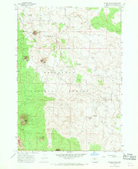
1967 Map of Kelsey Butte
USGS Topo · Published 1969About this map
Deschutes National Forest dominates this Central Oregon landscape, characterized by a series of volcanic peaks and subterranean lava tubes. The 1967 field-checked data captures a region defined by its geology, where prominent landmarks like Kelsey Butte, Horse Butte, and Coyote Butte rise above the high desert floor. Below the surface, an extensive system of caverns is documented, including the Skeleton Cave, Boyd Cave, and the Arnold Ice Cave.
Find a feature on this map
20 named features on this map. Tap any name to fly to it.
Don’t see what you’re looking for? This feature index may not catch every label — zoom into the map to look around manually.
Map Details
Editions of this 1967 Kelsey Butte Map
3 editions found
Other maps of this area

1926 · Bend
USGS Topo · 1:125,000

1929 · Bend
USGS Topo · 1:125,000

1931 · Newberry Crater
USGS Topo · 1:125,000

1935 · Newberry Crater
USGS Topo · 1:125,000

1955 · Crescent
USGS Topo · 1:250,000

1955 · Bend
USGS Topo · 1:250,000

1957 · Crescent
USGS Topo · 1:250,000

1957 · Bend
USGS Topo · 1:250,000

1958 · Crescent
USGS Topo · 1:250,000

1958 · Bend
USGS Topo · 1:250,000