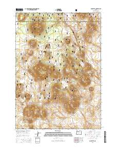
2014 Map of Fox Butte
USGS Topo · Published 2014About this map
Deschutes National Forest dominates this central Oregon landscape, where a series of volcanic buttes and ridges define the high-elevation terrain. This 2014 survey captures a section of the high desert and forest transition along the boundary of Deschutes Co Lake Co. Prominent peaks like Fox Butte, Aspen Butte, and the interestingly named Moohoo'oo Mtn rise above the flats. The map documents an extensive network of forestry access, including Natl Forest Develop Road 500 Rd and Natl Forest Develop Road 700 Rd, which connect remote landmarks like The Blowouts and Buzzard Rock. Several isolated water sources, such as Kitteredge Reservoir and West Reservoir, are scattered across the arid flats of Porcupine Flat and Watkins Flat, serving as critical points in an otherwise dry, timbered environment.
Find a feature on this map
25 named features on this map. Tap any name to fly to it.
Don’t see what you’re looking for? This feature index may not catch every label — zoom into the map to look around manually.
Map Details
Editions of this 2014 Fox Butte Map
This is the sole edition of this map. No revisions or reprints were ever made.
Other maps of this area

1955 · Crescent
USGS Topo · 1:250,000

1957 · Crescent
USGS Topo · 1:250,000

1958 · Crescent
USGS Topo · 1:250,000

1970 · Crescent
USGS Topo · 1:250,000

1981 · Fox Butte
USGS Topo · 1:24,000

1981 · Hogback Butte
USGS Topo · 1:24,000

1981 · Cougar Mtn
USGS Topo · 1:24,000
1981 · Plot Butte
USGS Topo · 1:24,000
1982 · Sixteen Butte
USGS Topo · 1:24,000
1982 · Firestone Butte
USGS Topo · 1:24,000