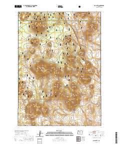
2020 Map of Fox Butte
USGS Topo · Published 2020About this map
Deschutes National Forest encompasses the majority of this high-desert landscape along the boundary of Deschutes and Lake Counties. The terrain is defined by a series of volcanic buttes and ridges, most notably Fox Butte in the northwest and Moohoo'oo Mtn in the south. The area’s hydrology is dominated by a collection of isolated water storage sites, including Kitteredge Reservoir, West Reservoir, and South Reservoir, which suggest the importance of water management in this arid environment.
Find a feature on this map
26 named features on this map. Tap any name to fly to it.
Don’t see what you’re looking for? This feature index may not catch every label — zoom into the map to look around manually.
Map Details
Editions of this 2020 Fox Butte Map
This is the sole edition of this map. No revisions or reprints were ever made.
Other maps of this area

1955 · Crescent
USGS Topo · 1:250,000

1957 · Crescent
USGS Topo · 1:250,000

1958 · Crescent
USGS Topo · 1:250,000

1970 · Crescent
USGS Topo · 1:250,000

1981 · Fox Butte
USGS Topo · 1:24,000

1981 · Hogback Butte
USGS Topo · 1:24,000

1981 · Cougar Mtn
USGS Topo · 1:24,000
1981 · Plot Butte
USGS Topo · 1:24,000
1982 · Sixteen Butte
USGS Topo · 1:24,000
1982 · Firestone Butte
USGS Topo · 1:24,000