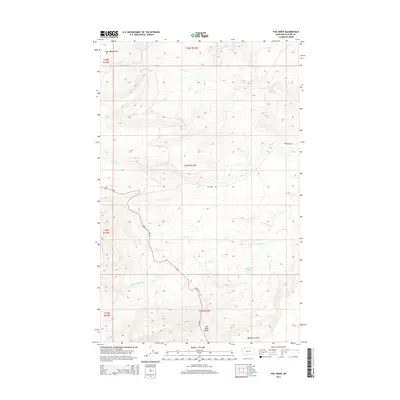
2014 Map of Fox Creek
USGS Topo · Published 2014About this map
Saint Mary Ridge and Milk River Ridge dominate this high-plains landscape in Glacier County, where the hydrology of the Continental Divide begins to shape the terrain. The S Fork Milk River flows through the southern half of the quadrangle, south of the tucked-away Josephine Lake. This region is defined by its drainage patterns, with Livermore Cr, Toad Cr, and Fox Cr cutting through the topography. Modern transportation follows established routes like Us 89, while the Fox Creek Trl and McDonald Rd provide access to more remote sections of the ridges. The survey illustrates the stark, unpopulated nature of this Montana borderland, where the names like Madman Coulee suggest a history of difficult travel and isolation.
Find a feature on this map
18 named features on this map. Tap any name to fly to it.
Don’t see what you’re looking for? This feature index may not catch every label — zoom into the map to look around manually.
Map Details
Editions of this 2014 Fox Creek Map
This is the sole edition of this map. No revisions or reprints were ever made.
Other maps of this area

1901 · Browning
USGS Topo · 1:125,000

1903 · Browning
USGS Topo · 1:125,000

1960 · Cut Bank
USGS Topo · 1:250,000

1963 · Cut Bank
USGS Topo · 1:250,000

1964 · Cut Bank
USGS Topo · 1:250,000

1968 · Saint Mary
USGS Topo · 1:24,000

1968 · Babb
USGS Topo · 1:24,000

1968 · Josephine
USGS Topo · 1:24,000
1968 · Cut Bank Pass
USGS Topo · 1:24,000
1968 · Kiowa
USGS Topo · 1:24,000