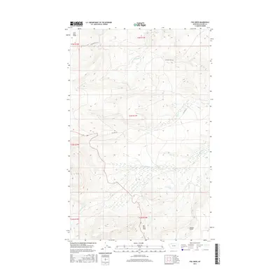
2017 Map of Fox Creek
USGS Topo · Published 2017About this map
Saint Mary Ridge and Milk River Ridge define the high terrain of this portion of Glacier County, Montana, marking a significant hydrological divide. The S Fork Milk River meanders through the central and southern sections, while smaller drainages like Fox Cr and Livermore Cr carve through the northern landscape. In the southeast, Josephine Lake sits as a prominent water feature near Madman Coulee. This 2017 survey reflects a largely undeveloped landscape where transportation is dominated by rural routes and trails such as the Fox Creek Trl and Livermore Truck Trl, which provide access to the interior. The presence of Highway 89 cutting through the western sections indicates the primary corridor for regional travel amidst this complex system of ridges and river forks.
Find a feature on this map
17 named features on this map. Tap any name to fly to it.
Don’t see what you’re looking for? This feature index may not catch every label — zoom into the map to look around manually.
Map Details
Editions of this 2017 Fox Creek Map
This is the sole edition of this map. No revisions or reprints were ever made.
Other maps of this area

1901 · Browning
USGS Topo · 1:125,000

1903 · Browning
USGS Topo · 1:125,000

1960 · Cut Bank
USGS Topo · 1:250,000

1963 · Cut Bank
USGS Topo · 1:250,000

1964 · Cut Bank
USGS Topo · 1:250,000

1968 · Saint Mary
USGS Topo · 1:24,000

1968 · Babb
USGS Topo · 1:24,000

1968 · Josephine
USGS Topo · 1:24,000
1968 · Cut Bank Pass
USGS Topo · 1:24,000
1968 · Kiowa
USGS Topo · 1:24,000