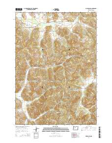
2014 Map of Fox Hollow
USGS Topo · Published 2014About this map
Fox Hollow sits within a landscape defined by sharp drainage divides and the headwaters of numerous creeks in this southwest Lane County region. The terrain is anchored by Round Mtn, from which a complex network of waterways like Boardtree Cr and Truman Cr descend into the valleys. The maps shows a settlement pattern of rural homesteads and hillside properties accessed by winding routes like the Lorane Hwy and Briggs Hill Rd, which serve the small communities of Briggs Hill and the quadrangle's namesake, Fox Hollow. To the north, the drainage of Spencer Cr and its S Fork Spencer Cr indicates the transition toward the larger Willamette Valley watershed. The prevalence of family-named roads such as Bailey Hill Rd and McBeth Rd provides a clear view of the longstanding land ownership and local genealogy of this timbered upland area.
Find a feature on this map
61 named features on this map. Tap any name to fly to it.
Don’t see what you’re looking for? This feature index may not catch every label — zoom into the map to look around manually.
Map Details
Editions of this 2014 Fox Hollow Map
This is the sole edition of this map. No revisions or reprints were ever made.
Other maps of this area

1909 · Elmira
USGS Topo · 1:62,500

1910 · Eugene
USGS Topo · 1:62,500

1921 · Cottage Grove
USGS Topo · 1:62,500

1922 · Elmira
USGS Topo · 1:62,500

1940 · Eugene
USGS Topo · 1:62,500

1942 · Elmira
USGS Topo · 1:62,500

1942 · Crow
USGS Topo · 1:62,500

1945 · Crow
USGS Topo · 1:62,500

1946 · Eugene
USGS Topo · 1:62,500

1949 · Eugene
USGS Topo · 1:62,500