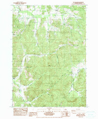
1984 Map of Fox Hollow
USGS Topo · Published 1984About this map
Spencer Creek and its southern fork wind through the northern reaches of this Lane County landscape, where the rural character of the early 1980s is defined by a network of drainage basins and prominent rises like Briggs Hill and Round Mountain. The settlement pattern centers around small crossroads and family-named landmarks, most notably Gillespie Corners in the west. A local focal point for the community is the Twin Oaks Sch, situated near the intersection of the Lorane Highway and Spencer Creek.
Find a feature on this map
27 named features on this map. Tap any name to fly to it.
Don’t see what you’re looking for? This feature index may not catch every label — zoom into the map to look around manually.
Map Details
Editions of this 1984 Fox Hollow Map
This is the sole edition of this map. No revisions or reprints were ever made.
Other maps of this area

1909 · Elmira
USGS Topo · 1:62,500

1910 · Eugene
USGS Topo · 1:62,500

1921 · Cottage Grove
USGS Topo · 1:62,500

1922 · Elmira
USGS Topo · 1:62,500

1940 · Eugene
USGS Topo · 1:62,500

1942 · Elmira
USGS Topo · 1:62,500

1942 · Crow
USGS Topo · 1:62,500

1945 · Crow
USGS Topo · 1:62,500

1946 · Eugene
USGS Topo · 1:62,500

1949 · Eugene
USGS Topo · 1:62,500