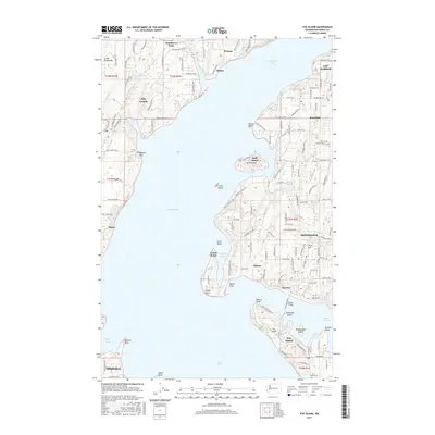
2017 Map of Fox Island
USGS Topo · Published 2017About this map
Fox Island sits at the center of this 2017 survey, connected to the mainland near Warren by the Island Bridge. The landscape of the Great Peninsula is defined by a dense network of inlets and coves, including Horsehead Bay, Glen Cove, and Mayo Cove. Residential development and local infrastructure are visible in established communities like Artondale, Rosedale, and Gig Harbor. The map detail shows the suburbanization of the Pierce County shoreline, where modern road grids like Woodhill Dr NW and Thomas Road KP N interface with natural features like Sylvia Lake and Lake Minterwood. Genealogists can locate the Fox Island Cem on the island's southern tip, while the geography of smaller landforms such as Cutts Island, Tanglewood Island, and Towhead Island illustrates the complex maritime environment of the Puget Sound and Carr Inlet region during the early 21st century.
Find a feature on this map
136 named features on this map. Tap any name to fly to it.
Don’t see what you’re looking for? This feature index may not catch every label — zoom into the map to look around manually.
Map Details
Editions of this 2017 Fox Island Map
This is the sole edition of this map. No revisions or reprints were ever made.
Other maps of this area

1937 · Olympia
USGS Topo · 1:62,500

1938 · Allyn
USGS Topo · 1:62,500

1940 · Anderson Island
USGS Topo · 1:62,500

1942 · Gig Harbor
USGS Topo · 1:62,500

1943 · Gig Harbor
USGS Topo · 1:62,500

1948 · Anderson Island
USGS Topo · 1:62,500

1948 · Anderson Island
USGS Topo · 1:24,000

1948 · Steilacoom
USGS Topo · 1:24,000

1949 · Olympia
USGS Topo · 1:62,500

1953 · Burley
USGS Topo · 1:24,000