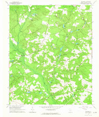
1964 Map of Foxtown
USGS Topo · Published 1965About this map
The South Fork Edisto River meanders through this portion of Aiken County, defining a landscape marked by small agricultural settlements and numerous local burial grounds. In the mid-1960s, the rural character of the region is evident through the distribution of family-named landmarks and water bodies, such as Cullums Pond and Huttos Pond. The map reveals a community centered around local spiritual and social hubs like Rocky Springs Ch and Magnolia Ch, each often accompanied by its own cemetery. Significant infrastructure like the Pipeline and secondary routes such as Notch Road and New Holland Road provide insight into the connectivity and industrial utility of the area during this era. Small-scale industry is present in the form of several claypits scattered across the terrain, reflecting the local geology and its role in the rural economy.
Find a feature on this map
48 named features on this map. Tap any name to fly to it.
Don’t see what you’re looking for? This feature index may not catch every label — zoom into the map to look around manually.
Map Details
Editions of this 1964 Foxtown Map
2 editions found
Other maps of this area

1920 · Aiken
USGS Topo · 1:48,000

1921 · Aiken
USGS Topo · 1:62,500

1943 · Aiken
USGS Topo · 1:62,500

1944 · Gilbert
USGS Topo · 1:62,500

1944 · Seivern
USGS Topo · 1:62,500

1954 · Augusta
USGS Topo · 1:250,000

1957 · Augusta
USGS Topo · 1:250,000

1958 · Augusta
USGS Topo · 1:250,000

1961 · Augusta
USGS Topo · 1:250,000

1962 · Augusta
USGS Topo · 1:250,000