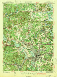
1943 Map of Framingham
USGS Topo · Published 1943About this map
Framingham and its surrounding Middlesex County landscapes are defined by a complex network of water management and institutional infrastructure in the early 1940s. The map captures a critical era of regional utility, showing the extensive Sudbury Reservoir and the interconnected Reservoir No 1 and Reservoir No 2 system alongside the Sudbury Water Supply. This functional landscape is punctuated by significant institutional landmarks, including the State Muster Grounds, the Sherborn Prison, and Bethany Convent.
Find a feature on this map
85 named features on this map. Tap any name to fly to it.
Don’t see what you’re looking for? This feature index may not catch every label — zoom into the map to look around manually.
Map Details
Editions of this 1943 Framingham Map
3 editions found
Other maps of this area

1886 · Blackstone
USGS Topo · 1:62,500

1886 · Framingham
USGS Topo · 1:62,500

1887 · Franklin
USGS Topo · 1:62,500

1887 · Marlboro
USGS Topo · 1:62,500

1889 · Marlboro
USGS Topo · 1:62,500

1889 · Blackstone
USGS Topo · 1:62,500

1889 · Franklin
USGS Topo · 1:62,500

1889 · Framingham
USGS Topo · 1:62,500

1893 · Franklin
USGS Topo · 1:62,500

1893 · Blackstone
USGS Topo · 1:62,500