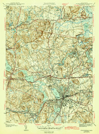
1943 Map of Framingham
USGS Topo · Published 1943About this map
The intersection of the Boston and Albany, Boston and Maine, and New York New Haven and Hartford railroads defines the mid-century landscape of Framingham. This 1940s-era snapshot shows a community transitioning from its agricultural roots to a regional hub, with specialized institutions such as Marist College, the State Teachers College, and Sherborn Prison established on the outskirts. Notable for genealogists are several family-named landmarks and schools, including the Marys Lamb Sch and Carding Mill Pond Sch near the historic Wayside Inn.
Find a feature on this map
73 named features on this map. Tap any name to fly to it.
Don’t see what you’re looking for? This feature index may not catch every label — zoom into the map to look around manually.
Map Details
Editions of this 1943 Framingham Map
3 editions found
Other maps of this area

1886 · Blackstone
USGS Topo · 1:62,500

1886 · Framingham
USGS Topo · 1:62,500

1887 · Franklin
USGS Topo · 1:62,500

1887 · Marlboro
USGS Topo · 1:62,500

1889 · Marlboro
USGS Topo · 1:62,500

1889 · Blackstone
USGS Topo · 1:62,500

1889 · Franklin
USGS Topo · 1:62,500

1889 · Framingham
USGS Topo · 1:62,500

1893 · Franklin
USGS Topo · 1:62,500

1893 · Blackstone
USGS Topo · 1:62,500