
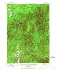
1929 Map of Franconia
USGS Topo · Published 1963About this map
The Gale River and Pemigewasset River valleys define this mountainous portion of the White Mountains, surveyed in 1929 before modern tourism transformed the region. At the heart of the landscape lies Franconia Notch Highway, passing the famous The Profile and Profile Lake. The infrastructure of the era is clearly visible, including the Boston and Maine RR terminating near Lincoln and the Logging RR tracing the East Branch Pemigewasset River. Early outdoor recreation is already established, marked by the Appalachian Trail, the Profile Golf Club, and several remote shelters like the Gale Head Shelter. In the south, small communities like North Woodstock and Fairview serve as hubs for the surrounding peaks, including Mt Lafayette and Kinsman Mtn.
Find a feature on this map
148 named features on this map. Tap any name to fly to it.
Don’t see what you’re looking for? This feature index may not catch every label — zoom into the map to look around manually.
Map Details
Editions of this 1929 Franconia Map
2 editions found
Other maps of this area

1893 · Mt. Washington
USGS Topo · 1:62,500

1895 · Crawford Notch
USGS Topo · 1:62,500

1896 · Mt. Washington
USGS Topo · 1:62,500

1896 · Crawford Notch
USGS Topo · 1:62,500

1900 · Whitefield
USGS Topo · 1:62,500

1928 · Plymouth
USGS Topo · 1:62,500

1928 · Rumney
USGS Topo · 1:62,500

1929 · Moosilauke
USGS Topo · 1:62,500

1931 · Littleton
USGS Topo · 1:62,500

1931 · Plymouth
USGS Topo · 1:62,500