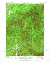
1929 Map of Franconia
USGS Topo · Published 1967About this map
The Daniel Webster Highway serves as the primary artery through this high-altitude corridor of the White Mountains, surveyed just before the era of modern interstate construction. The settlement of Lincoln and the neighboring North Woodstock anchor the southern valleys, while Franconia sits in the north, separated by the steep ascent of the Franconia Notch. The map documents an era of transition for the local economy, where traditional logging operations, represented by several Logging RR spurs, existed alongside a growing tourism and recreation sector.
Find a feature on this map
154 named features on this map. Tap any name to fly to it.
Don’t see what you’re looking for? This feature index may not catch every label — zoom into the map to look around manually.
Map Details
Editions of this 1929 Franconia Map
2 editions found
Other maps of this area

1893 · Mt. Washington
USGS Topo · 1:62,500

1895 · Crawford Notch
USGS Topo · 1:62,500

1896 · Mt. Washington
USGS Topo · 1:62,500

1896 · Crawford Notch
USGS Topo · 1:62,500

1900 · Whitefield
USGS Topo · 1:62,500

1928 · Plymouth
USGS Topo · 1:62,500

1928 · Rumney
USGS Topo · 1:62,500

1929 · Moosilauke
USGS Topo · 1:62,500

1929 · Franconia
USGS Topo · 1:62,500

1931 · Littleton
USGS Topo · 1:62,500