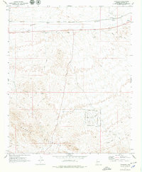
1970 Map of Franconia
USGS Topo · Published 1979About this map
Sacramento Wash and the Franconia Wash converge in this high-desert landscape, dominated by the northern reaches of the Mohave Mountains. The map illustrates a critical transportation corridor during the late 1960s, where the Atchison Topeka and Santa Fe railroad and a major pipeline parallel the wash. At the tiny settlement of Franconia, the railroad infrastructure meets the historic Old Trails Road. To the south, the terrain becomes increasingly complex, marked by numerous mineral extraction sites including the Boulder Mine and Yucca Mine, alongside scattered prospects. A nascent residential grid is visible in the southeast, with named thoroughfares like Wagon Wheel Dr and Coronado Road signaling modern development beginning to encroach on the traditional mining and ranching land.
Find a feature on this map
20 named features on this map. Tap any name to fly to it.
Don’t see what you’re looking for? This feature index may not catch every label — zoom into the map to look around manually.
Map Details
Editions of this 1970 Franconia Map
2 editions found
Other maps of this area

1903 · Needles
USGS Topo · 1:125,000

1904 · Needles Special
USGS Topo · 1:125,000

1927 · Yucca
USGS Topo · 1:62,500

1927 · Buck Mountains
USGS Topo · 1:62,500

1929 · Buck Mountains
USGS Topo · 1:62,500

1929 · Yucca
USGS Topo · 1:62,500

1943 · Topock
USGS Topo · 1:62,500

1950 · Topock
USGS Topo · 1:62,500

1951 · Topock
USGS Topo · 1:62,500

1954 · Needles
USGS Topo · 1:250,000