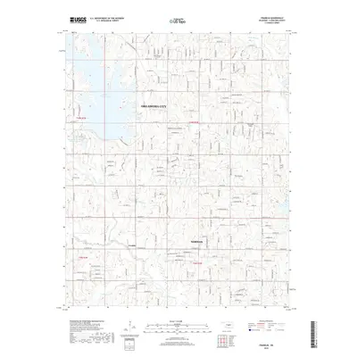
2018 Map of Franklin
USGS Topo · Published 2018About this map
Stanley Draper Lake dominates the northwest corner of this 2018 survey, reflecting the essential water infrastructure of central Oklahoma. The map documents a transitional landscape where the suburban edges of Oklahoma City and Norman meet more rural areas, including the small settlement of Franklin. Topographic contours reveal the drainage patterns of the Little River and Rock Cr, while the eastern portion is defined by the elevation of Thunderbird Ridge. Local history is anchored by several burial grounds, including the Ford-Pleasant Grove Cemetery in the north and the Blackburn Cemetery near the center of the sheet. The dense grid of residential streets and arterial roads like S Anderson Road and S Hiwassee Road illustrates the steady expansion of the metropolitan corridor between these major cities.
Find a feature on this map
126 named features on this map. Tap any name to fly to it.
Don’t see what you’re looking for? This feature index may not catch every label — zoom into the map to look around manually.
Map Details
Editions of this 2018 Franklin Map
This is the sole edition of this map. No revisions or reprints were ever made.
Other maps of this area

1892 · Moore
USGS Topo · 1:62,500

1893 · Norman
USGS Topo · 1:62,500

1898 · Purcell
USGS Topo · 1:125,000

1910 · McComb
USGS Topo · 1:62,500

1925 · Norman NO 2
USGS Topo · 1:24,000

1930 · McLoud
USGS Topo · 1:62,500

1934 · Crutcho Creek
USGS Topo · 1:24,000

1934 · Moore
USGS Topo · 1:62,500

1936 · Norman
USGS Topo · 1:62,500

1938 · Moore
USGS Topo · 1:62,500