
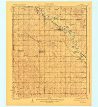
1930 Map of McLoud
USGS Topo · Published 1930About this map
The North Canadian River winds through this Central Oklahoma landscape, defining the topography and commerce of the late 1920s. The region is marked by a dense network of country schools, such as New Salem Sch, Minnehaha Sch, and Arkansas Flat Sch, reflecting a time of rural family farming and localized education. The Chicago Oklahoma & Gulf RR and the Rock Island and Pacific railroad lines intersect at McLoud, a critical junction for the area's agricultural economy. This transport network supported local industry, evidenced by the Moore & Nordin Gin located south of Dale. Cultural and community centers are anchored by landmarks like the Kickapoo Mission and various rural congregations including Bethel Ch. From the northern settlement of Harrah to the southern reaches of Pink, the map provides a look at the transition from tribal lands to an organized rural grid.
Find a feature on this map
65 named features on this map. Tap any name to fly to it.
Don’t see what you’re looking for? This feature index may not catch every label — zoom into the map to look around manually.
Map Details
Editions of this 1930 McLoud Map
2 editions found
Other maps of this area

1892 · Moore
USGS Topo · 1:62,500

1892 · Edmond
USGS Topo · 1:62,500

1893 · Norman
USGS Topo · 1:62,500

1896 · Seminole and Prague
USGS Topo · 1:125,000

1898 · Purcell
USGS Topo · 1:125,000

1905 · Chandler
USGS Topo · 1:62,500

1907 · Chandler
USGS Topo · 1:62,500

1907 · Maud
USGS Topo · 1:62,500

1908 · Maud
USGS Topo · 1:62,500

1909 · Shawnee
USGS Topo · 1:62,500