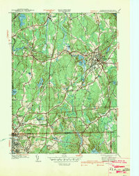
1939 Map of Franklin
USGS Topo · Published 1942About this map
Franklin serves as the primary hub of this late 1930s landscape, where the campus of Dean Academy stands near the intersection of the New York New Haven and Hartford RR lines. The survey captures the borderlands of Massachusetts and Rhode Island before mid-century suburbanization, showing a high density of named water bodies and wetlands such as Silver Lake, Beaver Pond, and the expansive Woodward Swamp. Further south, the map details the industrial and transport fringe of Woonsocket, including the Woonsocket Airport and the local landmark of Grants Mill. Rural life is marked by numerous family-named landmarks and civic centers like the Ballow Meetinghouse and S Franklin Ch, reflecting a deeply rooted community structure. The terrain is defined by a series of prominent rises, from Forge Hill to Diamond Hill, which dictate the winding paths of the region's historic roads and the course of the Charles River through North Bellingham.
Find a feature on this map
77 named features on this map. Tap any name to fly to it.
Don’t see what you’re looking for? This feature index may not catch every label — zoom into the map to look around manually.
Map Details
Editions of this 1939 Franklin Map
This is the sole edition of this map. No revisions or reprints were ever made.
Other maps of this area

1886 · Blackstone
USGS Topo · 1:62,500

1887 · Franklin
USGS Topo · 1:62,500

1887 · Providence
USGS Topo · 1:62,500

1889 · Providence
USGS Topo · 1:62,500

1889 · Blackstone
USGS Topo · 1:62,500

1889 · Franklin
USGS Topo · 1:62,500

1889 · Burrillville
USGS Topo · 1:62,500

1893 · Franklin
USGS Topo · 1:62,500

1893 · Blackstone
USGS Topo · 1:62,500

1894 · Burrillville
USGS Topo · 1:62,500