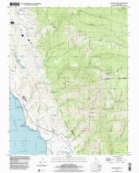
1998 Map of Franklin Point
USGS Topo · Published 2002About this map
Punta del Año Nuevo defines this coastal landscape where the Santa Cruz Mountains meet the Pacific. The rugged coastal shelf known as the Mesa gives way to the uplifted ridges of Butano Ridge and the steep elevations of the Chalks, culminating at Chalk Mtn. This late 20th-century survey illustrates a region dominated by vast preserved lands, including Butano State Park and Big Basin Redwoods State Park.
Find a feature on this map
47 named features on this map. Tap any name to fly to it.
Don’t see what you’re looking for? This feature index may not catch every label — zoom into the map to look around manually.
Map Details
Editions of this 1998 Franklin Point Map
This is the sole edition of this map. No revisions or reprints were ever made.
Other maps of this area

1897 · Palo Alto
USGS Topo · 1:62,500

1899 · Palo Alto
USGS Topo · 1:62,500

1902 · Santa Cruz
USGS Topo · 1:125,000

1940 · Halfmoon Bay
USGS Topo · 1:62,500

1940 · Ano Nuevo
USGS Topo · 1:62,500

1941 · Ano Nuevo Pt.
USGS Topo · 1:62,500

1941 · Palo Alto
USGS Topo · 1:62,500

1942 · Ano Nuevo
USGS Topo · 1:62,500

1943 · Palo Alto
USGS Topo · 1:62,500

1943 · Halfmoon Bay
USGS Topo · 1:62,500