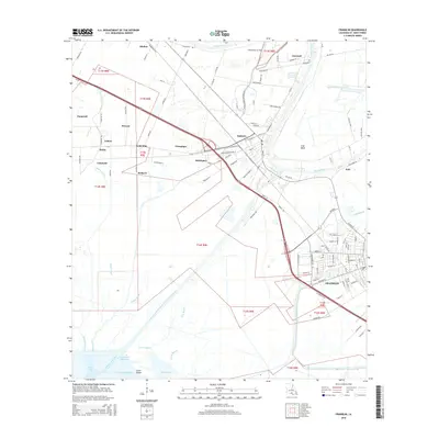
2015 Map of Franklin
USGS Topo · Published 2015About this map
Bayou Teche winds through the heart of this St. Mary Parish landscape, serving as the historical and cultural anchor for settlements like Baldwin and Franklin. The map illustrates a complex network of water management and transport, including the Intracoastal Waterway and the massive Charenton Drainage and Navigation Canal cutting through the marshy terrain toward Jaws Bay. Small rural communities and plantation-derived names such as Adeline, Caneland, and Gold Mine dot the corridor along Us 90, reflecting the region’s agricultural roots and its evolution into a modern transit hub. Further south, the map reveals a transition into the coastal wetlands of Lower Island and Mud Lake, where the Franklin Canal and Billy Bayou provide vital drainage. Local landmarks like the Chitimacha Air Park near the northern boundary and the neighborhood of Irish Bend highlight the unique cultural geography found along the Teche at this time.
Find a feature on this map
45 named features on this map. Tap any name to fly to it.
Don’t see what you’re looking for? This feature index may not catch every label — zoom into the map to look around manually.
Map Details
Editions of this 2015 Franklin Map
This is the sole edition of this map. No revisions or reprints were ever made.
Other maps of this area

1937 · Bayou Sale
USGS Topo · 1:62,500

1937 · Jeanerette
USGS Topo · 1:62,500

1941 · Belle Isle
USGS Topo · 1:62,500

1945 · New Orleans
USGS Topo · 1:250,000

1948 · Foster
USGS Topo · 1:62,500

1954 · Jeanerette
USGS Topo · 1:62,500

1954 · Belle Isle
USGS Topo · 1:62,500

1957 · Bayou Sale
USGS Topo · 1:62,500

1959 · Foster
USGS Topo · 1:62,500

1963 · New Orleans
USGS Topo · 1:250,000