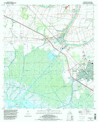
1994 Map of Franklin
USGS Topo · Published 1998About this map
The town of Franklin and the adjacent settlement of Baldwin define this coastal Louisiana landscape, where the winding Bayou Teche historically dictated the layout of sugar plantations and early commerce. Large landholdings like Bodin Plantation and Lucy Plantation are visible alongside smaller agricultural communities such as Ashton, Katy, and Adeline. The region's industrial footprint is marked by the Jeanerette Oil and Gas Field and the Franklin Gas Field, while the Southern Pacific railroad provides a primary transportation corridor parallel to the bayou.
Find a feature on this map
44 named features on this map. Tap any name to fly to it.
Don’t see what you’re looking for? This feature index may not catch every label — zoom into the map to look around manually.
Map Details
Editions of this 1994 Franklin Map
This is the sole edition of this map. No revisions or reprints were ever made.
Other maps of this area

1937 · Bayou Sale
USGS Topo · 1:62,500

1937 · Jeanerette
USGS Topo · 1:62,500

1941 · Belle Isle
USGS Topo · 1:62,500

1945 · New Orleans
USGS Topo · 1:250,000

1948 · Foster
USGS Topo · 1:62,500

1954 · Jeanerette
USGS Topo · 1:62,500

1954 · Belle Isle
USGS Topo · 1:62,500

1957 · Bayou Sale
USGS Topo · 1:62,500

1959 · Foster
USGS Topo · 1:62,500

1963 · New Orleans
USGS Topo · 1:250,000