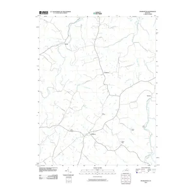
2010 Map of Franklinton
USGS Topo · Published 2010About this map
Bethlehem and the central settlement of Franklinton anchor this Henry County landscape, where the northern drainage of Drennon Creek meets the southern flow of the Salt River. The map reveals a deeply etched topography of ridges and hollows, notably James Ridge and Happy Ridge, which dictated the winding paths of rural routes like Hickory Corner Rd and Sewell Rd. Genealogists will find significant local history preserved at the Sewell Cemetery and Point Pleasant Cemetery, along with smaller named communities such as Delville and Slabtown. The area is defined by its intricate network of waterways, including the curiously named Holy Water Branch and Fool Hollow, illustrating how the Kentucky terrain shaped local nomenclature and settlement patterns into the early 21st century.
Find a feature on this map
51 named features on this map. Tap any name to fly to it.
Don’t see what you’re looking for? This feature index may not catch every label — zoom into the map to look around manually.
Map Details
Editions of this 2010 Franklinton Map
This is the sole edition of this map. No revisions or reprints were ever made.
Other maps of this area

1906 · Lockport
USGS Topo · 1:48,000

1908 · Lockport
USGS Topo · 1:62,500

1928 · New Castle
USGS Topo · 1:48,000

1932 · New Castle
USGS Topo · 1:62,500

1950 · New Liberty
USGS Topo · 1:24,000

1952 · Worthville
USGS Topo · 1:24,000

1952 · Campbellsburg
USGS Topo · 1:24,000

1953 · Gratz
USGS Topo · 1:24,000

1953 · Polsgrove
USGS Topo · 1:24,000
1954 · New Castle
USGS Topo · 1:24,000