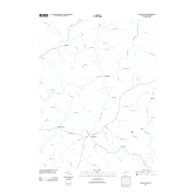
2013 Map of Franklinton
USGS Topo · Published 2013About this map
Bethlehem and Franklinton anchor this rural Henry County landscape, where the terrain is defined by the winding course of the Salt River and its numerous tributaries. The map details a network of ridges and hollows, notably Happy Ridge and James Ridge, which separate the drainage basins of Fivemile Cr and Drennon Cr. The small community of Point Pleasant sits near its namesake Point Pleasant Cem, while Sewell Cem is located further east near Slabtown. These features, along with names like Drennon Falls and Fool Hollow, illustrate the traditional naming conventions of north-central Kentucky. The road system follows the natural topography, with routes like Point Pleasant Rd and Franklinton Rd connecting isolated farmsteads and small settlements. This survey provides a clear view of the area's geography before significant modern development altered the rural character of the river valley.
Find a feature on this map
75 named features on this map. Tap any name to fly to it.
Don’t see what you’re looking for? This feature index may not catch every label — zoom into the map to look around manually.
Map Details
Editions of this 2013 Franklinton Map
This is the sole edition of this map. No revisions or reprints were ever made.
Other maps of this area

1906 · Lockport
USGS Topo · 1:48,000

1908 · Lockport
USGS Topo · 1:62,500

1928 · New Castle
USGS Topo · 1:48,000

1932 · New Castle
USGS Topo · 1:62,500

1950 · New Liberty
USGS Topo · 1:24,000

1952 · Worthville
USGS Topo · 1:24,000

1952 · Campbellsburg
USGS Topo · 1:24,000

1953 · Gratz
USGS Topo · 1:24,000

1953 · Polsgrove
USGS Topo · 1:24,000
1954 · New Castle
USGS Topo · 1:24,000