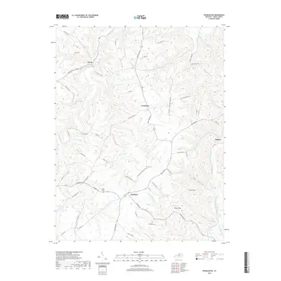
2019 Map of Franklinton
USGS Topo · Published 2019About this map
Bethlehem and Franklinton anchor the upland ridges of Henry County, where the landscape is defined by the deep incisions of the Drennon Creek and Sixmile Creek drainages. The topography here dictates a winding network of rural roads, such as Woods Pike and Bethlehem Rd, which follow the contours of James Ridge and Happy Ridge. These elevations separate the varied local watersheds, including those of Fivemile Cr and Flag Run, which eventually feed into the broader Salt River valley to the south. Small family and community landmarks like Jenkins Cem, Willhite Cem, and Sewell Cem are scattered across the terrain, reflecting the long-standing agricultural settlement patterns of this Kentucky region. The presence of smaller hamlets like Delville and Slabtown further illustrates the historical importance of local crossroads and creek-side communities in the late 2010s.
Find a feature on this map
72 named features on this map. Tap any name to fly to it.
Don’t see what you’re looking for? This feature index may not catch every label — zoom into the map to look around manually.
Map Details
Editions of this 2019 Franklinton Map
This is the sole edition of this map. No revisions or reprints were ever made.
Other maps of this area

1906 · Lockport
USGS Topo · 1:48,000

1908 · Lockport
USGS Topo · 1:62,500

1928 · New Castle
USGS Topo · 1:48,000

1932 · New Castle
USGS Topo · 1:62,500

1950 · New Liberty
USGS Topo · 1:24,000

1952 · Worthville
USGS Topo · 1:24,000

1952 · Campbellsburg
USGS Topo · 1:24,000

1953 · Gratz
USGS Topo · 1:24,000

1953 · Polsgrove
USGS Topo · 1:24,000
1954 · New Castle
USGS Topo · 1:24,000