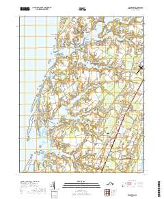
2019 Map of Franktown
USGS Topo · Published 2019About this map
Occohannock Neck and the intricate finger-like points of the Virginia Eastern Shore define this landscape, where the Chesapeake Bay meets a complex network of creeks and coves. The map documents a coastal economy and infrastructure ranging from the Machipongo International Airport to the historic site of The Saltworks near Bayford. Small settlements like Treherneville, Machipongo, and Birdsnest are clustered along the primary north-south transit corridor, while the western shore is marked by distinct geographic features such as Shooting Point and Silver Beach. The interior is characterized by a mix of agricultural fields and woodlands, broken by water bodies like Drummonds Millpond and Purnell Pond. This layout illustrates the long-standing maritime orientation of Northampton County, where land use follows the natural contours of Hungars Creek and Nassawadox Creek.
Find a feature on this map
141 named features on this map. Tap any name to fly to it.
Don’t see what you’re looking for? This feature index may not catch every label — zoom into the map to look around manually.
Map Details
Editions of this 2019 Franktown Map
This is the sole edition of this map. No revisions or reprints were ever made.
Other maps of this area

1942 · Cheriton
USGS Topo · 1:24,000

1942 · Cobb Island
USGS Topo · 1:24,000

1942 · Nassawadox
USGS Topo · 1:24,000

1943 · Nassawadox
USGS Topo · 1:31,680

1943 · Jamesville
USGS Topo · 1:31,680

1943 · Franktown
USGS Topo · 1:31,680

1943 · Exmore
USGS Topo · 1:24,000

1943 · Richmond
USGS Topo · 1:250,000

1944 · Exmore
USGS Topo · 1:31,680

1946 · Eastville
USGS Topo · 1:250,000